The importance of antenna elevation for LTE Internet
- Intro
- How much elevation do I need?
- How to locate a cell tower
- How to improve CellMapper.net’s data
- Filtering out multiple antenna towers
- Create a topological map
Intro
LTE works best when both ends of the connection (your antenna and the cell tower) have a line of sight to each other. Any obstacles, such as building, trees, or hills that are between them, degrade the quality of their connection.
In many situations, the best way to get, or come closer to line of sight is to add elevation to your antennas.
How much elevation do I need?
How much elevation do you need? That depends on how good the coverage is at your home. If you get a strong enough signal throughout your home, then elevation doesn’t matter much, but for many homes, just moving your antenna to the top floor helps considerably. At my home, for example, I get an Internet connection that’s many times faster on the top floor than I do from the basement.
If moving your antenna to your home’s top floor or attic isn’t enough, then it’s time to consider an outdoor installation.
It’s possible that just getting above the roofline is sufficient, but before making that kind of investment, I recommend doing the following:
- Find out where the cell tower that you’re connecting to is
- Create a topological map of what lies between you and the cell tower
- Look at the map to estimate if you need to clear the roofline, or go higher
How to locate a cell tower
The easiest way to find out a cell tower’s location is to ask your cellular Intenet provider. If they can tell you, then great - skip ahead to the Create a topological map section. Otherwise, read on.
If your cell provider can’t or won’t tell you where their towers are, then I recommend using CellMapper.net to get an estimate.
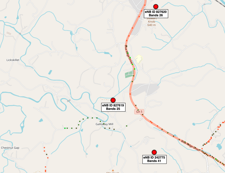
Here’s an example CellMapper.net map that shows nearby towers on bands 25, 26 and 41:

Here’s how to generate a map:
- Sign up for an account. The free tier is sufficient at this stage.
- Use the First Time Startup guide to find the tower.
CellMapper.net generates its maps based on data submitted by its users, so they might not have enough data already to tell you where the nearest towers are. If they don’t, then the next section shows how to improve their data.
How to improve CellMapper.net’s data
If you have an Android phone, then you can improve CellMapper.net’s data about your area’s LTE coverage. It often takes CellMapper days to process new data, so keep that in mind as you plan things out. They do have a paid tier that generates data faster, but even with it, I’ve found that there’s about a 24 delay for updating maps.
Here’s how to improve CellMapper.net’s data for your area:
- Get an Android phone that works on the same network that you wish to use for Internet access.
- Sign up for a CellMapper.net account. The free tier works unless you want to pay them for faster data processing.
- Install the app on your Android phone, then open it and log in.
- Drive or walk around your local area while the CellMapper.net app is running in the foreground. I found that driving a few miles in each direction was most helpful, but even going for a walk around the block can improve the map somewhat.
- When you get back home, upload your results by tapping:
- The hamburger menu
- Upload and Statistics
- Upload
Filtering out multiple antenna towers
If your cell provider or CellMapper.net show multiple nearby towers, then you can narrow down the possibilities by using any of the following methods:
- If you have any antennas aimed yet, then compare the direction that they’re pointing to the tower locations.
- The CellMapper app should show you which bands you get a signal on at your home. Compare those bands to the bands that CellMapper shows each tower provides.
- Create a topological map of the between you and each candidate cell tower. Rule out the towers for which there doesn’t appear to be a viable path.
Create a topological map
After you’ve identified where a tower is, you can create a topological map that shows what lies between you and the tower. Doing that allows you to simulate different antenna elevations.
Ubiquiti has published a link analysis tool to https://link.ui.com/ that can generate a topological map between two points, and estimate the radio propagation characteristics. For example, here’s the map that I generated while researching my home Internet connection options:
« Previous: Select Hardware Next: Install Hardware »
